Whether you’re looking for somewhere to stroll in the sun, a new route to walk the dog, or a wintery wonderland to explore with the family, there are plenty of walks and trails around Middlesbrough.
Albert Park walking trail
This is a gentle and level walk around Albert Park. It has surfaced footpaths all the way around the park and links areas of natural, historic, and artistic interest.
- Walk distance: 1.25 miles
- Walking time: 45 minutes to 1 hour
- Start and finish: Visitor Centre. Find it on Google Maps here.
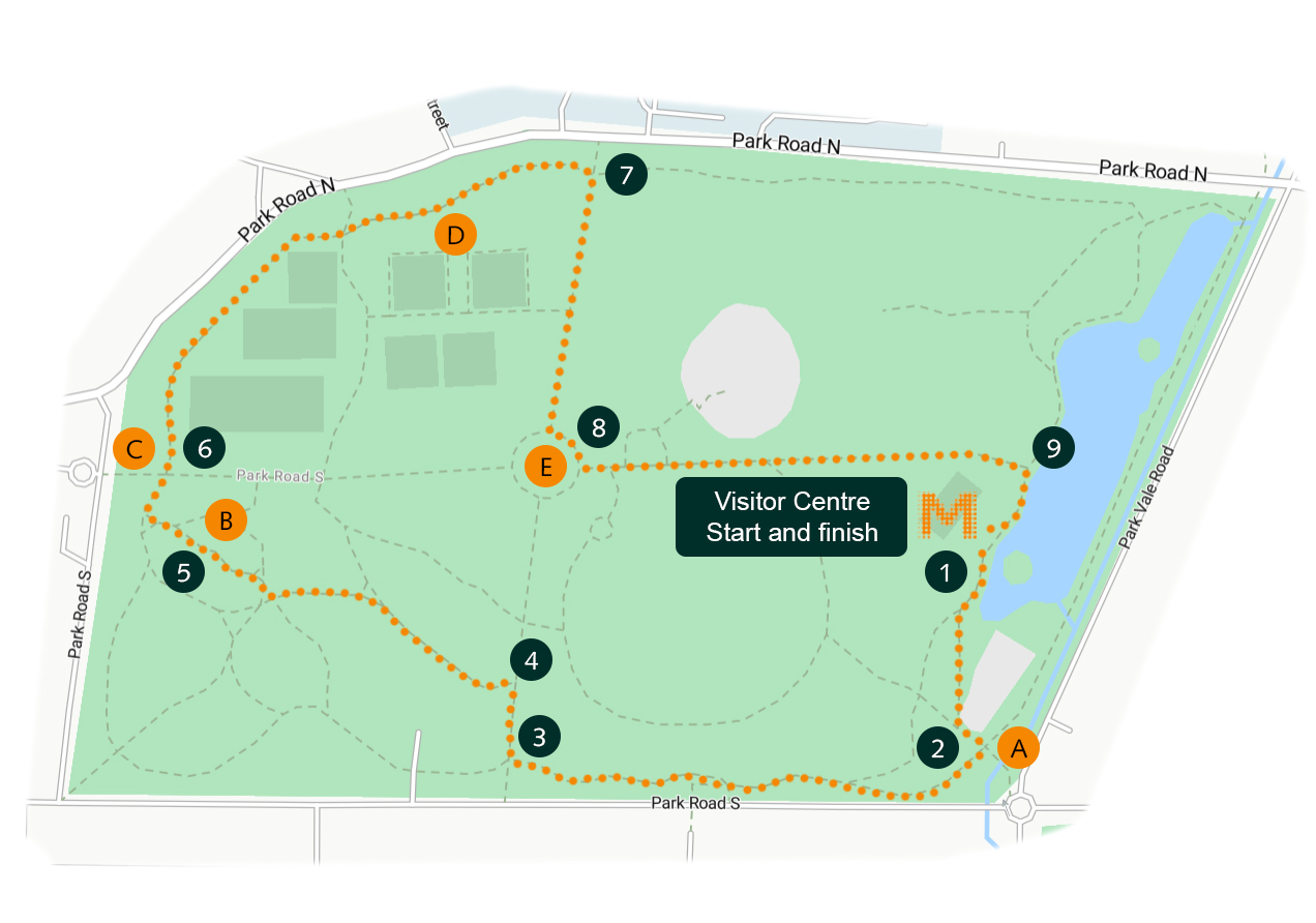
Directions
- Starting from the visitor centre and café near the lake, turn right and walk past the boat house. Bear left and pass the children’s play area. Just before the foot bridge and gate you’ll see the metal sculpture of the Galloping Horseman.
- A: The Galloping Horseman – The beginning of the Marton West Beck Trail which finishes in Coulby Newham. The Horseman statue represents the packhorse trails across ancient Cleveland which were the only method of transporting goods over long distances on land before the advent of the canals and railways during the industrial revolution.
- Return to the path and turn left to join a wider path. Continue slightly uphill with the fire station over your road to your left.
- After 300 metres, turn right and walk towards the central fountain.
- After 50 metres, take the first path left and follow a series of paths for 250 metres towards the statue of Brian Clough.
- From the Brian Clough statue head towards the main entrance gates and clock tower.
- B: Brian Clough Statue – Part of the Brian Clough Trail, it represents the famous footballer ‘Cloughie’ in this twenties making his way from his home on Valley Road through Albert Park to train at Middlesbrough’s old ground at Ayresome Park.
- Pass the clock tower and follow the track passing a large cannon. Follow the path for 400 metres around the edge of the park, passing the tennis courts and the Message Tree.
- C: Tower clock and cannon – The Grade II listed black and gold tower clock was donated to the park by Alderman Tomas Sanderson in 1900. The cannon was taken from Sevastapol during the Crimean War in the 1850s. On the right is the Grade II listed sundial gifted from Henry Bolckow in 1879.
- D: The Message Tree – An ancient hawthorn, one of Middlesbrough’s heritage trees. Before the park was laid out, a footpath known as the Sailor’s Trod ran from Newport to North Ormesby. Sailors using the path left messages for each other under a piece of ironstone in the tree. The ironstone is still there and the tree has grown around it.
- Near the north entrance gate, turn right and walk towards the central fountain and bandstand.
- After 200 metres turn left at the fountain and walk down between an avenue of trees towards the lake.
- E: Fountain – The black and gold fountain was donated in 1869 by Joseph Pease of Darlington. It features statues of herons on the central column topped by swans and lily pads. To the right is the bandstand, a replica of the original Victorian structure
- On reaching the lake, after 300 metres turn right to return to the visitor centre.
Fairy Dell walking trail
This is a beautiful walk to explore Fairy Dell lake, woodland, and park. There are some steep gradients and steps and the path can be muddy or slippery in wet weather.
- Walk distance: 1.5 miles
- Walking time: 45 minutes to 1.5 hours
- Start and finish: Newham Grange Farm, Wkyeham Way, Coulby Newham, TS8 0TG. Find it on Google Maps here.
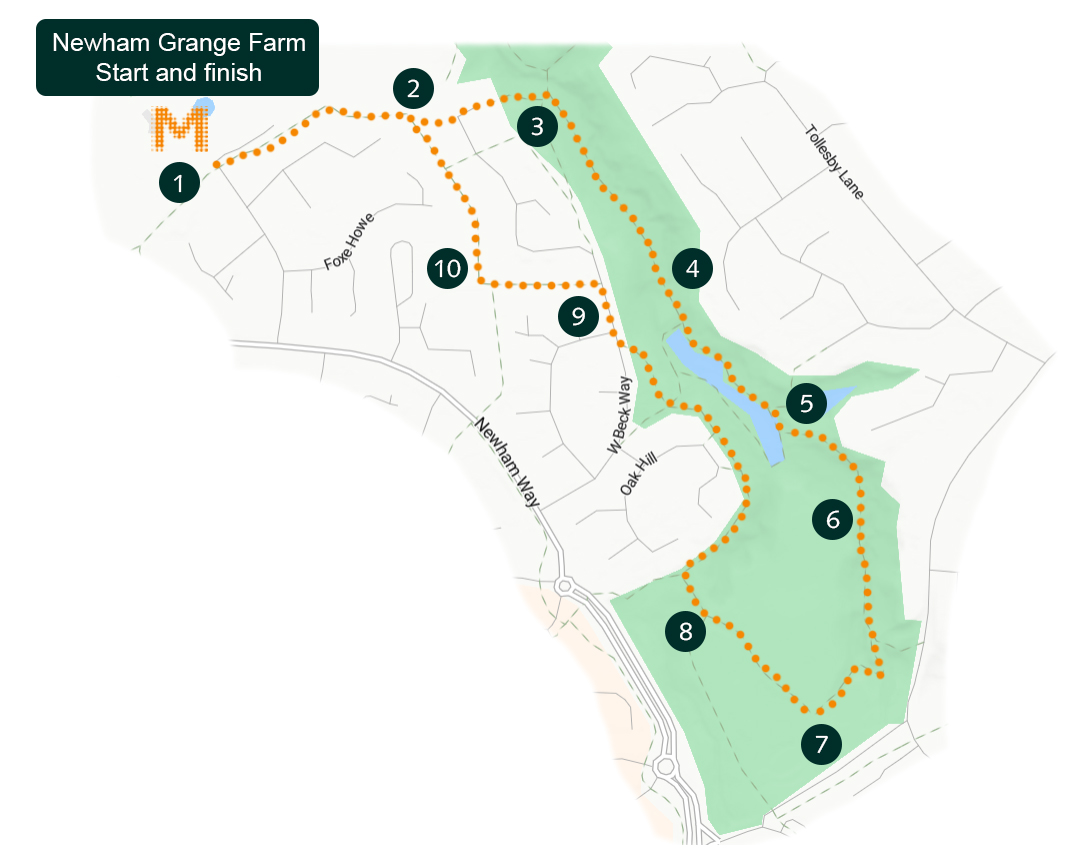
Directions
- From Newham Grange Farm car park entrance, turn left to follow the walkway with the fields on your left.
- After 240 metres turn left along a stone track. After 55 metres turn right and follow the path between the houses for 60 metres. Turn left and follow the path down the steps through the trees.
- Cross over the cycle path and follow the stone track with the beck on your left.
- Cross the bridge and continue up the hill past the metal sculpture of the witch, the bird hide, and the information board, then cross the waterfall bridge.
- Ignore Beck Bridge over the beck at the end of the lake. Instead, follow the wiggling path. Cross the back at Snake Bridge and turn right to climb the steps.
- At the top of the steps turn left up the narrow path between the trees. Turn left again and follow the edge of the park land.
- On reaching the paved path, turn right and follow it through the park
- Go through the gate and turn right. Turn right again at the next path junction. Follow the walkway beside the cycle path for the next 500 metres.
- On reaching the blue signposts, turn left and cross the road.
- Go straight ahead to next blue sign that reads ‘Newham Grange Leisure Farm 1/2’. Turn right and follow the walkway beside the cycle path back to the start of the walk.
Stewart Park walking trail
This gentle walk through Stewart Park is enjoyable for all ages. The route is accessible to all with a constructed path and plenty of seating.
- Walking distance: 1.3 miles
- Walking time: 30 minutes to 1 hour
- Start and finish: Stewart Park main car park on Ladgate Lane. Find it on Google Maps here.
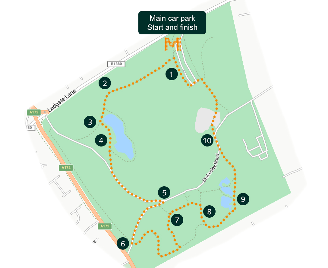
Directions
- From the main car park, follow the tarmac footpath that runs parallel to Ladgate Lane for 280 metres. Continue through the trees and across the grassy open space. Follow the footpath to an area of seating with carvings of aboriginal art work.
- Continue for another 80 metres, bearing right at the fork and take the second left turn into a footpath, which runs along the side of the Lower Lake through the trees.
- Follow the path for 380 metres through the trees, passing by the Lower Lake viewing platform. The platform provides fantastic views of the park over the lake and was the site of the former boat house.
- Continue on the main path up a slight incline until you reach a junction with a wide path in the woods that leads to the Captain Cook Birthplace Museum.
- Turn right, and after 170 metres turn left just before the East Lodge.
- After 100 metres you reach the Sensory Gardens. Turn right and follow the path for almost 300 metres, continuing to bear left at all forks until you reach the Promenade.
- Bear right at the fork and follow the path for 185 metres, passing the Promenade on your left. Bear right, heading away from the Captain Cook Birthplace and passing the Granite Vase on your right.
- Continue along the path for 160 metres through the wood, bearing left at the next three forks until you reach the Upper Lakes.
- Follow the path for 110 metres passing by the lakes on your left. Leaving the lakes, bear right for 200 metres until you arrive at the play area near the Henry Bolckow Visitor Centre.
- Follow the path through the play area, passing by the World Map and animal enclosures on your right, to the car park and the end of the walk.